
In this edition, we will learn about the history of Nosara, its origins, the original peoples, the Nicoya Party and its annexation to Costa Rica, the establishment of the Nicoya Canton and the Nosara District, and a particular fact, which is the establishment of the “Proyecto Americano” and how it influenced what is now one of Costa Rica’s most exclusive tourist destinations.
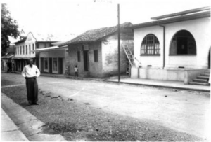
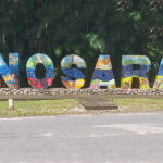
The Pacific coast of Costa Rica’s Guanacaste region includes the historic town of Nosara, which lies six kilometers inland, and is famous for its beaches. It is situated 55 kilometers southwest of Nicoya and 266 kilometers west of San Jose.
Here is some history of that town, beginning with the origin of Guanacaste, then the birth of Nicoya Canton, and finally a short history of Nosara.
Guanacaste
Costa Rica’s fifth province is located in the country’s extreme northwest. It shares borders with the Pacific Ocean to the west, the Republic of Nicaragua to the north, the Province of Alajuela to the east, and the Province of Puntarenas to the south.
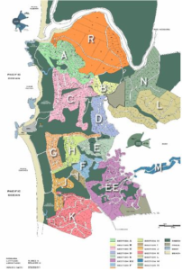
It covers an area of 10,140 km2. It is the second-largest province in the country but the least populous, with only 326,953 inhabitants. Within it, there are 11 cantons and 61 districts. San José, Costa Rica’s capital, is located 210 kilometers from Liberia, which is the main city of Guanacaste. Santa Cruz and Nicoya are two further important cities.
Guanacaste’s borders include the majority of the former Partido de Nicoya (territorial subdivision), which the country acquired on July 25, 1824. The Guanacaste mountain range’s volcanic peaks and broad plains that face the Pacific Ocean combine to provide its beauty.
The two main geological features are the Santa Elena Peninsula in the northwest and the Nicoya Peninsula, which is the largest in the country and includes the Gulf of Nicoya.
The annexation of Nicoya
Nicoya got its name from the “Cacique Nicoa” chief of the Chorotegan, which is the original group of inhabitants when the Spanish arrived.
Pre-Colombian indigenous people from different “Chorotegas” groups lived in this area. The many items, including glass, jade stones, gold, mud, and stone that were found on the highest hills, as well as the graves where the highest-ranking Indians were buried, along with their jewelry and accessories, provide examples of this proof. These priceless accessories and outfits were all stolen in the past, and most of them are currently in the hands of private collectors.
The annexation of the Nicoya region to Costa Rica is recorded as a historical event since it refers to the incorporation of the territory of Nicoya to Costa Rica on July 25, 1824.
During a vote that was held in the city of Nicoya, the residents of the municipalities of Nicoya and Santa Cruz decided to join Costa Rica.
Villa de Guanacaste’s inhabitants (Liberia) declined to join, but on March 18, 1825, the Federal Republic of Central America’s Congress enacted a law incorporating their population into Costa Rica.
Nicoya Canton
Guanacaste was divided into the cantons of Bagaces and Cañas, Villa Guanacaste (Liberia), Nicoya, and Santa Cruz by decree dated December 7, 1848. These cantons were further subdivided into districts. The cantons, including Villa Guanacaste, took the place of the “departments” under the Constitution on November 22, 1848. The president of the republic would select the province governor, who would reside in Villa Guanacaste, and each canton would have a political chief and a municipality.
Costa Rica ultimately succeeded in having Nicaragua recognize the annexation of Nicoya in the Cañas-Jerez pact of 1858, which was later acknowledged by the Cleveland Award of 1888.
According to legend, among those who lived there was a Chorotega princess named Nosara, the daughter of the powerful Chief Nicoa, who is said to have fallen in love with Curime, the son of a high ruler who lived in a town near Nicoya.
The legend includes a wonderful and sad love story in which Nosara and Curime are murdered during a beautiful sunset on what is now known today as the beautiful beach of Nosara.
Nosara District
According to Agreement No. 40 of January 26, 1988, on the establishment and limits of regions of Guanacaste, Nicoya is recognized as a canton as of the year 1848 and Nosara is designated as a district.
The settlement is roughly 4 meters above sea level and situated in a valley that receives irrigation from the Nosara River. Beautiful hills on each side of it offer breathtaking views of the valley and the sea.
The names of this town are Boca del Nosara or Bocas de Nosara.
This district has a total area of 134.92 km2 and an estimated population of 4,920 people, according to the 2011 Population Census.
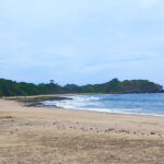
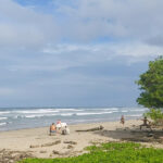
Playa Nosara is part of the Ostional Wildlife Refuge, which also includes Playa Guiones and Playa Pelada, which belong to Nicoya, and Playa Ostional, which belongs to Santa Cruz. Here, several sea turtles assemble to lay their eggs.
Economics
Since the Chorotegas, trade, and agriculture have been the mainstays of Nicoya’s economy. In the early 1900s, the upper Nicoya canton was first populated for agricultural purposes.
Through Santa Cruz, another group of settlers started colonizing more land with carts. The parish records for Nicoya and Santa Cruz list these pioneer settlers.
Boats served as the alternate mode of communication, carrying mail and agricultural products to the port of Puntarenas along the coastline.
The colony sparked the growth of animal husbandry in the Tempisque River valley, and today, tourism serves as the foundation for all other types of economic activity.
American Project
For many years, the region close to Nosara was mostly used as a cattle pasture. The natural beauty of the area was dramatically diminished as large tracts of land had their trees cut. However, a group of foreigners who made reforestation a key priority established one of the first ex-pat communities in the area in the 1970s.
The Nosara American Project, which encompasses properties at the northern end of Playa Guiones, Playa Pelada, and some of the neighboring hills, is an excellent example of intelligent planning and development.
The well-planned development on about 3,000 acres that became known as “the American Project” had an 18-hole golf course and about 700 lots at first.
Even though the initial developers’ promise of a golf course was never realized, a sizable amount of that land is now preserved and under the management of the Nosara Civic Association. The 22 separate land parcels totaling 77 hectares, or almost 170 acres, make up this permanent Green Zone.
By the mid-1970s, there was no genuine road, only a cart trail. By the 1980s, there was a gravel road that was typically in bad shape and had several river crossings, but it was part of a larger project called Route 160.
Municipal power was first offered in the early 1980s. Landline phone service commenced in 1999, while cellular phone service started in 2002. Before that, CB radios were typical home objects used for communication.
All of the modern comforts are now available to you, including fast Internet, cable and satellite TV, fully stocked supermarkets, and a wide variety of dining alternatives.
Route 160
This route is a mostly gravel road that roughly follows the southern coast of the Nicoya Peninsula. It is paved from the end of Route 21 at the Naranjo ferry terminal south to the Paquera ferry terminal. It then heads west, passing the Tambor beach and airport on its way to Cóbano. During the dry season, the northwest-bound section of the road from here to Puerto Carrillo is only accessible by off-road vehicles. There are numerous river and stream crossings where there are no bridges.
The path continues in a general northwesterly direction from Puerto Carrillo, but it becomes a good-condition gravel road that can be driven all year.
It passes several tourist destinations and beaches, including Sámara, Nosara, and the Ostional Wildlife Refuge. At Veintisiete de Abril, the road curves northeast paves itself, and continues until it rejoins Route 21 in Santa Cruz.
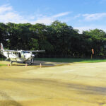
Route 160 is critical to Nosara’s growth since it is the only land communication route and the second access way after the landing strip.
The construction of Route 160 in the segment that accesses Nosara has suffered several setbacks due to non-compliance with the construction and the poor general condition of the road, and it is the cause of ongoing disagreements between the government and the Nosara inhabitants.
Now the route is mostly paved, but bridges are still under construction.
Nosara Real State
The Beaches of Nosara American Project was initially inspired by developer Mr. Alan D. Hutchison. The original Playa Guiones land buyers launched a lawsuit against what was left of the development company he had established, Inversiones Nicoya, S.A. (“INSA”). INSA reportedly violated its contractual obligations, according to the buyers.
According to reports, a complex and cunning solution was developed — the plaintiffs were reportedly given ownership of property that had been transferred from Finca 7302 (perhaps owned by INSA) onto Finca 24113-B — as an apparent response to this case and apparently to pacify the plaintiffs.
The Nosara Civic Association, one of the parties to this agreement, has been fighting against Richmond Phipps, the head of the business that owns Finca 24113-B, Custodia de Propiedades Guanacastecas, S.A.
According to the Registro’s (Costa Rican property registration office) most recent actions, the people who were duped in the INSA settlement and those who later purchased land from INSA after Hutchinson left, seem to be the victims of the numerous Nosara homeowners who have been sold plots in the Nosara area with a questionable title.
It appears that we are all currently experiencing the same pain as a result of the double-dealing of certain initial developers and their successors, as well as an ineffective and very likely fraudulent land registration process.
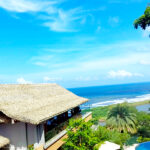
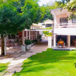
However, Nosara is regarded as a good area for housing boutique hotels and an ethnically diverse community with stores and dining options. The price per square meter varies from $1,250 to $3,839.
It is said that whoever bathes in the Nosara River remains in Nosara. This basically means that folks who know Nosara well are more likely to want to stay in Nosara, so they either rent long-term or buy a Nosara home.
The British daily “Financial Times,” which focuses on business and economic problems, reported on how real estate values have climbed significantly over the past two years of the pandemic.
They said that recently, foreigners have begun to travel to locations like Nosara and Santa Teresa to purchase homes and relocate close to the breathtaking natural beauty that the area’s forests and beaches offer.
The study does, however, go into great detail about the potential environmental effects of this expedited occurrence in Costa Rica.
The destruction of the tropical forest, unauthorized building techniques, and wastewater dumping into the waterways are only a few of the concerns.
Because the province of Guanacaste’s water deficit is another issue that affects the inhabitants, a guaranteed source of water must be reachable to receive building permission.
The article focuses on how Costa Rica’s reputation as an environmentally friendly nation may be impacted by the increase in building and real estate sales in this region.
Conclusion
Here is some background information to help frame the current situation in a region known for its beauty and tranquility, as well as its gorgeous beaches, excellent for surfing.
As you can see, Nosara’s remoteness and the efforts of individuals who have lived there have preserved its wonderful environment.
Other elements, such as the Nicoya Blue Zone, superb conditions for surfing and yoga, and a wide range of hotels and restaurants, explain why Nosara is a boutique destination for discerning travelers.
All of these aspects will be covered in subsequent articles.
- Nosara vs. Tamarindo: Your Ultimate Guide to Choosing the Perfect Costa Rican Destination – A Gypsy Cab Nosara Exclusive
 Embark on a picturesque journey to Nosara and Tamarindo with Gypsy Cab Nosara. Discover the tranquil beaches, vibrant surf spots, and culinary delights that await in these Costa Rican paradises. Your adventure begins here!
 - 10 Articles You Can Read on National Geographic About Costa Rica
 Explore the vibrant world of Costa Rica through ten insightful articles from National Geographic. Discover the country's rich biodiversity, culinary revolution, conservation efforts, and unique cultural practices.
 - Costa Rica’s Journey to Independence: A Tapestry of Resilience and Unity
 Embark on a rich and vibrant journey through Costa Rica's path to independence. Discover the significant events, notable figures, and cultural narratives that have shaped this remarkable nation. Engage with the past and explore the promising road ahead, as we celebrate the spirit of 'Pura Vida' in modern Costa Rica.
 - Nosara vs. Santa Teresa: A Comprehensive Guide for Tourists by Gypsy Cab Nosara
 Explore the contrasting charms of Nosara and Santa Teresa with our comprehensive guide. From serene beaches to vibrant nightlife, discover which Costa Rican gem aligns with your travel dreams. Brought to you by Gypsy Cab Nosara.
 - Introduction to Playa Guiones
 Discover the beauty and charm of Playa Guiones, a surfer's paradise nestled in Nosara, Guanacaste. Learn about its rich biodiversity, unique culture, and the range of activities and services it offers.
 - Gypsy Cab Nosara Shuttle Service to Boutique Hotel Lagarta Lodge: An In-Depth Review
 Experience the magic of Nosara with Gypsy Cab Nosara's shuttle service and discover the luxury and sustainability of the Boutique Hotel Lagarta Lodge. Dive into our in-depth review and let Costa Rica's gem captivate you
 - Nosara vs. Samara: A Detailed Comparison to Help You Choose Your Ideal Costa Rican Destination
 Discover the hidden gem of Costa Rica in our ultimate Nosara travel guide. Explore stunning beaches, world-class surf breaks, lush wildlife reserves, and a thriving yoga scene. Start planning your trip to Nosara today!
 - Gypsy Cab Nosara Shuttle Service to The Gilded Iguana Surf Hotel: A Comprehensive Review
 Experience the magic of Nosara with The Gilded Iguana Surf Hotel. Dive into our comprehensive review, from its rich history to modern amenities, and discover the convenience of the Gypsy Cab Nosara shuttle service from Liberia Airport.
 - Your Comprehensive Guide to Flying to Nosara, Costa Rica
 Plan your trip to Nosara, Costa Rica with our comprehensive guide. Learn about flight options, airlines, booking tips, and more to ensure a smooth journey.
 - Experience Unforgettable Beach Vacations with BeachManagementNosara
 Experience unforgettable beach vacations with Beach Management Nosara. Choose from a variety of luxurious vacation houses, each offering a unique blend of comfort, luxury, and a close connection to nature. Enjoy top-notch amenities and services, including property management, vacation rentals, and concierge services, all designed to ensure a memorable stay in Nosara, Costa Rica.